
Sat, Jun 1 2013 - Waterfall Hike/Dundas Valley (SLOWPOKE HIKE - 13 km) (View Original Event Details)
| 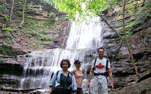 |
Grey skies and the threat of thunderstorms couldn't stop 12 gung-ho hikers from turning out for this mellow and scenic hike in the Dundas Valley Conservation Area on June 1, 2013. Highlights: five waterfalls, a sulphur spring, three ruins, two lookouts, some lovely Carolinian woods and periodic stretches along the jagged rocks, cliffs and gorges of the Niagara Escarpment. Oh, and for some – ice cream at the Trail Centre.
- According to Colin’s GPS (thanks, Colin!):
- Total distance covered 13.8 km
- Moving pace: 4.1 km/h
- Overall pace, including stops: 2.7 km/h (but we lingered at Griffin House and the Trail Centre and for photo).
- Total walking time: 3 hours, 22 minutes
- Total hike time: 5 hours and 10 minutes (not including the drive).
- Total generous drivers: 3 (thanks, Ron, Tatiana and Julianne!)
- Total number of great people: 12 – thanks for the happy, friendly attitudes, everyone!
Overall, the hike was quite flat with one long hill climbing up a road, one steeper descent switchbacking down, and a few shorter hills. There were only a few areas where we pick more carefully over and around some rocks but it was generally an easy and very well- maintained trail.
According to Environment Canada, the temperature reached a high in Hamilton of about 26 C that day – it didn't seem that hot on the trail, but the humidity was as close to 100 per cent as it can get without it actually raining. Some of us had more water rolling down our foreheads than we saw in one of the waterfalls (Heritage Falls, I’m talking to you!).
We parked at Tiffany Falls, which had a $10 per car fee and – note to self – no washrooms. We strolled along a charming but short (800 metres round trip) trail to the falls itself – a pretty, 21-metre high cascade waterfall.
Then we crossed very busy Wilson Avenue to reach the main trail. We followed this along until we reached Old Dundas Road and crossed again to get on the main Bruce Trail on the other side. Soon we saw beautiful Sherman Falls, a 17-metre-high curtain waterfall.
From here, we climbed a hill and followed a fenced-off field before dipping back into the woods and following the edge of the escarpment. We came across another small falls – Canterbury Falls.
We met up with the Heritage Trail loop and continued to the right, through more beautiful woods and the scenic rocks of the escarpment.
Then the trail climbed a small hill to the old Gatehouse, where we found a better view of the small Hermitage Falls – which look more like a short waterslide. We followed some country roads for a while until spotting Griffin House on the right. The sun was out, there was a nice breeze on the hill and – to the delight of many – there were clean Portapotties! – so we decided to break for lunch here.
After we had trouble finding the trail that was listed on our trail guide from the Toronto Hiking site – and finally realized we should walk from the driveway along the side of the house closest the road until reaching the opposite side of the house, where a wide grassy trail sloped gently downward to the next trail intersection.
We did a short side looping, heading left along the Homestead Trail. It was only 0.5 km and clearly wasn’t a popular trail, since it was overgrown with grass and had some marshy areas. We found out why when we reached the Heritage Falls – or rather the dry gorge where it would have been if there had been any water! Apparently this falls only runs in early spring and after an awful lot of rain. However, it had some nice shots of the escarpment and a crumbling ruin beside it. Overall, though, the group seemed to feel we could have skipped this loop.
We went back to the intersection and turned left, crossing Sulphur Springs Road to join the Main Loop Trail again. Soon we came to The Hermitage Ruins, a few stone walls still standing after a fire destroyed a Scottish immigrant’s summer home in the 1930s. We also seemed to interrupt what appeared to be a man having a “private” picnic lunch to propose to his loved one. Oh, well! If they wanted privacy, they should have gone to Temagami!
We went down a fairly steep switch-backing hill to the Sulphur Springs area, then looped up through the forest to the Trail Centre. Drinking water refills! Indoor Toilets! Photo opps on the train! Ice cream! Oh, and some cool displays of the flora and fauna of the area…
Heading back to the Main Loop trail, we followed it along until we reached the Monarch Trail.
It started to rain just before we reached the side trail that leads to Groundhog Hill. This apparently has a great panoramic view of the countryside (and according to the printed trail guide, a young man reading a book to his girlfriend…..) but since the rain and threat of lightning made us decide it would be smarter this time to keep on trekking.
We passed more nice views off the edge of the escarpment before looping around to pass a large building (the Resource Management Centre) and turned left along Artaban Road, huffing and puffing our way up a long hill then down pass some houses until we reconnected with the roads that run past Sherman Falls.
Finally we picked our way back along the connector trail to our cars.
Huzzah!
Have some photos from this event that you'd like to share in our photo album? Please forward them to Erik Sonstenes at photos@torontooutdoorclub.com. Please note that we prefer to receive the photos in approximately 640x480 or 750x500 pixels - do NOT send original high-res photos. If you have a LOT of photos, please submit up to twenty of your favorites (only) for a day event, or up to forty of your favourites for a multi-day event. Thank you.