
Sat, Sep 12 2009 - Explore the Eramosa Karst Conservation Area (View Original Event Details)
| 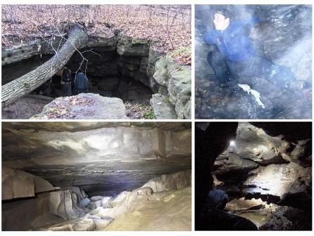 |
Are you ready for an adventure? Well 22 people we’re and we did NOT disappoint with this event. We set off from the trail head around 10:45 am. The plan was to explore this brand new conservation area. At the main entrance we find a shelter with a number of interpretive panels. They contain a great deal of information concerning the area, the land donation, the caves, and the unique features. The pavilion itself is designed to represent the landscape: the effect of water moving above and under ground. Rain falls on the roof of the shelter, drains down through the support beams and into channels at the base. From the entrance, we picked up a map and we took the orange trail to the right. Our first stop was Potruff Spring. Water flows underground through layers of limestone from other areas and springs up out of the ground. The water flows into a small wetland before disappearing again underground. Our next stop was the Old Quarry/Amphitheater. As you continue along the orange trail you will cross a boardwalk through the amphitheatre. I have been told this area can be full of flowing water when the rains are heavy, and you can see the way the water has eroded the area. This location was also used as a small quarry to build homesteads in the late 1800s. Our next stop was the Potruff Cave. Where the yellow trail meets the orange trail, make a right hand turn onto the yellow trail. A few meters along you will arrive at the Potruff Cave. A small opening at the base of the cave leads to the underground stream. I have been told that at times you will see water flowing out of the left hand side of the cave wall and it will disappear down into the sinkhole at the bottom of the cave. This cave was carved out by the flow of spinning water draining into the sinkhole. Follow the yellow trail and you will arrive at an area where the Stewart Creek disappears completely underground. This area is known as the Stewart Creek Sink. Our next stop was the Nexus Cave This cave is no more than a crack in the ground. Humans can’t fit through it, but water can flow through easily. However some of us tried! This water flow connects to the Nexus Window Cave entrance about a hundred meters away. Finally the highlight of the trip, the Nexus Window Cave. This is the entrance to the cave where people can enter and explore. The cave is 355 meters long and is the 10th longest cave in Ontario. Just our luck we meet up with Marcus Buck(B. SC. P.Geo) and his 2 young sons. Marus is one of the lead geologist working on the cave and one of the main drivers to designate this area as an earth science Area of Natural and Scientific Interest (ANSI). With a few well timed Q&A's, Marcus gave use a crash course in caving at least the first 25 meters. From the Window Cave you would have to crawl through a tunnel for about 25 metres before arriving at an underground waterfall where the cave opens up. The first part of the cave is about ˝ meter high and about 2 meters wide and of course the floor is wet. It was carved out by water. The first part of the cave is also littered with some broken bottles. You see the local farmers would use the cave as their garbage dump. So gloves, knee pads, elbow pads and a helmet would be good things to have along. Once you get by the first few meters the passage starts to gain depth. The roof of the cave was lined with Pyrite. Pyrite is the classic "Fool's Gold". When you shin your flashlight these shinny gold face cubes reflect the light. Very pretty!. About 15 meters later you arrive at a vertical waterfall shaft that drops down about 2-3 meters. This is far as our TOC group went since most of us where only equipped with flashlights and cameras. The chamber could fit easily 8 of us. We took some photos and a few movies and returned to the surface to let the next group in. About 3-4 waves of our group spent about 2 hours here exploring the cave. Most of the people tried and really like the experience. We picked a few wild apples, visited the old Potruff homestead (concrete foundation pad), picked a few wild pears, and finished off at the Watercress Sink (a creek disappears into the ground). Back in the parking lot, we took a final group photo to prove we started and ended with 22 people. A liitle different from your normal hike! At 2.4 km it probably was the shortest hike the TOC every put on! See you all soon. Gary BACKGROUND INFO: The Eramosa Karst is an outstanding example of karst located within the City of Hamilton in an area that is undergoing rapid urban expansion. It contains numerous diverse karst features: sinkholes, sinking streams, dry valleys, caves and springs. The scientific and educational value of this karst was first recognized by karst experts in 2000. At that time, the land was managed by the Ontario Realty Corporation and was slated for development. The former City of Stoney Creek put a development hold on the area pending scientific study. In April 2003, geoscientists completed an evaluation of the values of the karst and the Ministry of Natural Resources (MNR) formally recognized its significance by designating the area as an earth science Area of Natural and Scientific Interest (ANSI). The Province of Ontario has since donated the "Core Area" of the Eramosa Karst ANSI to the Hamilton Conservation Authority (HCA), in October 2006. The HCA has constructed a trail network with interpretive panels throughout the property, as well as parking facilities and an interpretive kiosk at the main entrance. They officially open the Eramosa Karst Conservation Area in 2008 as part of their 50th anniversary celebrations. This park will provide the public with a great opportunity to learn about karst. It also provides an excellent site for university-based research. Marcus Buck, B.Sc., P.Geo studied karst geology and geochemistry as a graduate student at McMaster University under the supervision of Dr. Derek Ford, a worldrenown expert in karst. He has been an avid caver since his youth and is a recognized expert in the caves and karst of Ontario. As a consultant, he developed a comprehensive cave management plan for Parks Canada based on an inventory of 230 caves on the Bruce Peninsula. He has evaluated some of the key karst areas of Ontario as earth science Areas of Natural and Scientific Interest for the Ministry of Natural Resources. He has also consulted for the private sector conducting hydrogeological investigations, including the evaluation of hazardous sites and environmental planning. Mr. Buck is a resident of Hamilton and played a key role in the establishment of the Eramosa Karst Conservation Area. He was the lead author of the MNR report that led to its designation as an ANSI, and he is currently participating in the development of the site as a conservation area. Mr. Buck has led more than 20 tours of the Eramosa Karst for agency staff , politicians and the public.
Have some photos from this event that you'd like to share in our photo album? Please forward them to Erik Sonstenes at photos@torontooutdoorclub.com. Please note that we prefer to receive the photos in approximately 640x480 or 750x500 pixels - do NOT send original high-res photos. If you have a LOT of photos, please submit up to twenty of your favorites (only) for a day event, or up to forty of your favourites for a multi-day event. Thank you.