
Tue, Aug 11 2009, Wed, Aug 12 2009, Thu, Aug 13 2009, Fri, Aug 14 2009, Sat, Aug 15 2009, Sun, Aug 16 2009 - Kayak Trip - Georgian Bay - Killarney & Phillip Edward Island (View Original Event Details)
|  |
The trip started from Downsview at 8 am on a Tuesday morning. We had two vehicles for 9 people and all our gear with Bernadette meeting us at the outfitters.
The day was a little overcast but nice for driving. The weather forecast was for 5 days of sunshine with little wind with highs around 20-25C. The drive north went faster than expected and my crowd stopped at the French River museum for a quick tour.
We had lunch at the French River Trading Post Hungry Bear restaurant. Simon and his crew drove into Killarney for lunch at the fish place.
After lunch we picked up our park vehicle permits at Killarney Park George Lake and loaded up our kayaks at Killarney Outfitters (check out the photos). A short shuttle (5km) put us at the Chikanishing River put in.
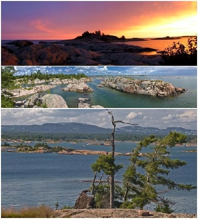
It took about an hour for everyone to stuff their kayaks with all their gear. It was a short paddle down the river and into Georgian Bay to our first campsite just outside the parks boundary (3.4 km). We set up camp on a beautiful smooth red rock site near Thomas Bay. The views were very nice. We all started to get to know each other. Most of us went swimming. The water was a bit cool but very refreshing. Some of us went for a short evening paddle after supper (4 km).
Most of us got chased into our tents after dark due to the mosquitoes. The sound outside my tent sounded like an DEEP WOODS OFF commercial.
Day 2 started off with nice clear blues skies and a light breeze. At first we thought we had a homeless person joining our group. But it was only Bahman, sleeping curled up in his sleeping bag on the rocks (with the mosquitoes). Simon snoring drove him out of the tent. It must have been bad if you think sleeping with mosquitoes is better! Back to the cars for another tent and we started our day with some big water crossings (since it was so calm). We headed over to One Tree Island, Mocking Bird Island and West Fox Island for lunch.
West Fox Island is a beautiful island (have a look at the photos). There were a few campers on the island and we had a conservation with a pair of canoeist. Rob had a foldable canoe. Simon and I tried it for a short spin. I think I’ll stick to the traditional Kevlar ones. On the island we ran into a snake and watched it for a while. After lunch we headed north east back into the protected waters and ended up on Red Crow Island (just south of Big Rock Point). We covered 19.6 km today.
The island rocks where rounded with lots of good sites. Lots of swimming before and after supper. Once it got dark we sat around watching (Perseids) shooting stars (about 1 every minute or so) with a small fire to keep us toasty. Not many bugs on this island. Mark gave us a lesson on start gazing with his star chart. And yes, Mark was correct, about Jupiter rising in the eastern sky just after sunset and Cassiopeia is a constellation in the northern sky. Mark you really know your stuff!
Day 3 started off with a nice clear blues skies and a light breeze. The plan today was do a little inland waterways and head for The Chichens (islands). We headed NE to Bear Bay and discovered the Philip Edward Map (by The Adventure Map company) was missing some marsh details. No problem, we’ll paddle/walk our way to the other side. Some exciting moments for Tamara with 2 leeches in her boat and me with no finger nails to pick them up. We survived that one!. We worked our way through various channels and Beaverstone Bay and headed south into The Chickens.
The Chickens are a group of rounded islands/rocks mostly with no trees on them. Our plan is to head east to Hen Island through the maze of islands. Hen Island has a nice U shape sandy bay on the leeward side of the island. Perfect for setting up camp and landing our kayaks in. At this point we are about 8 km from the French River Old Voyager Channel entrance. We covered 13.9 km today. There was not much wood on the island so Simon and I decided to go find some on the islands to the north. It took some effort but we both returned with tonight’s supply of fire wood. We had a nice group fire with most of us finding a comfortable spot. Check out the photos. I think Mark is asleep? That;s how he stays up to midnight and beyond star gazing!
Day 4 started off with nice clear blues skies and a light breeze. Again! We were hoping for more wind this morning to do some sailing but it was dead clam again. Our plan today is to head north to Colins Inlet and east to Mill Bay. Since it was so calm we headed west to the breakwater side of The Chickens and into Beaverstone Bay where we tied 3 or 4 kayaks together and used 2 paddles and a tent fly to sail up the bay. We peak out at around 5 km/hr. We sailed about 5 km under wind power, until our stomachs signaled that it was time for lunch and a swim. After lunch we headed west for the opening of the Colins Inlet, except Mark who decided to head south. We flagged down a yacht to give Mark the message he was heading the wrong way. I think Mark figured it before the people gave him the message. Anyways it all worked out. We had a rest and Mark got a workout. He also got very wet with Bahman’s bailing pump. That will show him! Heading west into the inlet brings a change of scenery. The inlet is a fault line with steep cliffs in some places. The north shore is native lands. We had a quick peak at one of the hunting shacks tucked away in the woods. Great signs (check out the photo).
Once we got to the Mahzenazing River we got a group photo at the old lumber mills pier pilings. In Mill Bay we found our campsite on Archers Island. Tamara caught a Small Mouth Bass and we cooked it on the fire. The fish was sweet and very nice. There were a few mosquitoes out as it got dark and a hint of rain, so I just headed for the tent. We covered 22.1 km today.
Day 5 started off overcast. Our mission today is to paddle west in Colins Inlet and find the native pictographs on the stone cliffs. There located about 2.2 km west of Mill Lake on the north side of the inlet about 2.5 meters above the water line. We found them! The main pictograph depicts a canoe (ribs) with a cross in it. This might depict Christian missionaries travels in the early 1600’s in this area. The second pictograph is a triangle shaped bird or man figure. Next to this is some old carving into the stone of someone’s initials “E.J.L.” and “1939”.
We continued west along Colins Inlet and stopped for lunch. It started to lightly rain and we eat our lunch under the trap. The rain did not last long and it stated to clear up as we arrived at the western entrance to the inlet. As we rounded South Point (ie west end of Philip Edward Island) the wind picked up a bit and we actual had some 1 foot high waves to work our way through. We headed south east and stopped for camp at Etches Island. Our travel distance today is 18.2 km.
The island has some trees on it. On the lower part there must have been a fire a few years ago because there are many burnt trees. The island is covered in blueberry and raspberry bushes. The skies are clearing again and we have a beautiful sunset again! Our campfire focus tonight is on bannick making and eating. No bugs for our last night and we stay up close to midnight.
Day 6 started off with a nice clear blues skies and no wind. Again!. A weasel or mink (more likely) is part of this island. Tamara and I spot one swimming and diving for food in the morning. It came ashore with a crawfish and quickly chews it down and heads back into the woods for safety once it sees me taking photos of it.
Last day. Back to Chikanishing River and our vehicles for the big pack up. Our paddle distance is 3.6 km. Back to the outfitter to unload the kayaks. We decide to have a lunch at the fish and chip trailer in Killarney. The place is busy!. Some nice white fish and a drink and an ice cream rounds off a great trip with a great group. The drive home was fairly easy with a little delay in the Barrie area.
Total group paddling distance was 80.8 km.
Best week of the whole summer. We must have horseshoes or something!
Thanks all, for the experience.
Gary
Have some photos from this event that you'd like to share in our photo album? Please forward them to Erik Sonstenes at photos@torontooutdoorclub.com. Please note that we prefer to receive the photos in approximately 640x480 or 750x500 pixels - do NOT send original high-res photos. If you have a LOT of photos, please submit up to twenty of your favorites (only) for a day event, or up to forty of your favourites for a multi-day event. Thank you.