
Sat, Nov 28 2009 - Long Sault Conservation Area (View Original Event Details)
|  |
At the crack of dawn, on a cool, overcast November day, a group of TOC hikers came together and set out for a brisk day hike at the Long Sault Conservation Area. Hmmm, have you had your coffee yet?
This was my first time on this trail and I looked forward to exploring the area. During the drive to the trail head, the sun and patches of clear sky appeared and then disappeared intermittently. Alas, the day's weather remained true to forecast: cool, breezy and cloudy.
After a group shot, we stared hiking around 9am and completed the eastern 7.2 km of trails in just over an hour and a half. Hmmm, fast group, only slightly slowed down by a single, extended muddy patch of ground.
A short break later, we moved out to hike the western trail sections. The highest points in the park, including a couple of lookouts atop some knolls can be found here. The western trails are also narrower and hillier. Nonetheless, the group maintained its momentum: we were back at the trail head by 1:15pm, having hiked a total of 19.2 km in about 4 hours (a moving average of 4.8km/hr including rest stops).
With the better part of the day still ahead of us, we took our last set of photos, said our goodbyes and headed back to Toronto. Good to see some new faces, good to see some old faces. Thanks to everyone who came out on this hike. Thanks too for the drivers, and for Gary and Victor for helping out with my first TOC event.
Note: If you'd like to send in your photos, please email them after resizing them to: gary.ataman@messier-dowty.com
Trail Notes:
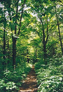
Long Sault has well maintained, easy to navigate, wide trails, and (mostly) gentle, rolling terrain with a few short, steep sections. Approximately 20km of trails available in connecting loops. Light to medium tree/brush density. The signage was extensive with good visibility, notably the "steep hills" warning for fast movers. In addition to hiking, the trails are open to MTBikers, snowshoeing and cross-country skiing. Good road access to the trail head/parking lot (day use fee: $4). Facilities on site. Driving time from Downsview: 1 hour/90km.
Have some photos from this event that you'd like to share in our photo album? Please forward them to Erik Sonstenes at photos@torontooutdoorclub.com. Please note that we prefer to receive the photos in approximately 640x480 or 750x500 pixels - do NOT send original high-res photos. If you have a LOT of photos, please submit up to twenty of your favorites (only) for a day event, or up to forty of your favourites for a multi-day event. Thank you.